Luxembourg (Province du Luxembourg)
 |
 |
It has an area of 4,459 km2, making it the largest Belgian province. With around 285,000 residents, it is also the least populated province, with a density of 64 /km2, making it a relatively sparsely settled part of a very densely populated region, as well as the lowest density in Belgium.
It is significantly larger (71%), but much less populous than the neighbouring Grand Duchy of Luxembourg. About eighty percent of the province is part of the densely wooded Ardennes region. The southernmost region of the province is called Gaume or Belgian Lorraine (main city: Virton). The Arelerland or Arlon region (in red on the map of arrondissements, below) bordering the neighbouring Grand-Duchy of Luxembourg has the particularity that many of its residents have historically spoken Luxembourgish, a language closely related to German, rather than the French or Walloon spoken elsewhere in the province.
The province was separated from the neighbouring Luxembourg by the Third Partition of Luxembourg, de jure in 1830–31 by the Conference of London dealing with the consequences of the Belgian Revolution of 1830, de facto in 1839, after William I, King of the Netherlands and Grand Duke of Luxembourg, agreed to its decisions and thus the province was given to the newly created Kingdom of Belgium.
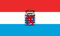
An unofficial flag of the province exists, with the actual colours of Luxembourg (red, white, and blue), as well as the province's coat of arms on the foreground.
Luxembourg province is divided into five administrative districts (arrondissements) containing a total of 44 municipalities (communes).
Map - Luxembourg (Province du Luxembourg)
Map


Country - Belgium
 |
 |
| Flag of Belgium | |
Belgium is a sovereign state and a federal constitutional monarchy with a parliamentary system. Its institutional organization is complex and is structured on both regional and linguistic grounds. It is divided into three highly autonomous regions: the Flemish Region (Flanders) in the north, the Walloon Region (Wallonia) in the south, and the Brussels-Capital Region. Brussels is the smallest and most densely populated region, as well as the richest region in terms of GDP per capita. Belgium is also home to two main linguistic communities: the Flemish Community, which constitutes about 60 percent of the population, and the French Community, which constitutes about 40 percent of the population. A small German-speaking Community, numbering around one percent, exists in the East Cantons. The Brussels-Capital Region is officially bilingual in French and Dutch, although French is the dominant language.
Currency / Language
| ISO | Currency | Symbol | Significant figures |
|---|---|---|---|
| EUR | Euro | € | 2 |
| ISO | Language |
|---|---|
| NL | Dutch language |
| FR | French language |
| DE | German language |